
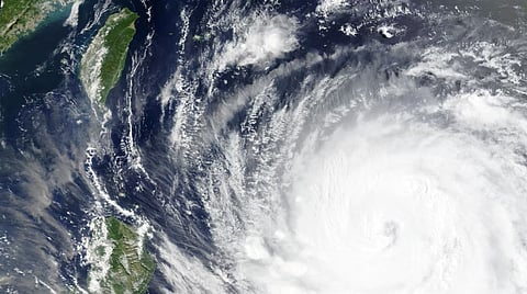
Typhoon Bavi: What we know as El Niño fuels fears of stronger storms
Typhoon Bavi is bearing down on Taiwan and eastern China, with forecasters warning it could rank among the region's most destructive storms in years. Scientists say the return of El Niño, combined with record-warm oceans, is creating conditions for more powerful tropical cyclones.
Taiwan has warned of up to one metre (3.3 feet) of rain in mountains north of Taipei and placed about 29,000 troops on standby, the defence ministry said, according to Reuters.
Packing winds nearing 200kph (124mph), Bavi stretches roughly 1,000km (621 miles) across — about the width of France. China's National Meteorological Centre expects the storm to brush northern Taiwan before making landfall in Fujian province on Saturday evening.
Forecasters say Bavi could be Taiwan's strongest typhoon since Kong-rey in 2024 and the island's largest by size since 1987, according to the Central Weather Administration.
Taiwan's Taoyuan International Airport said all Saturday departures by Taiwanese airlines had been cancelled.
Japan's Meteorological Agency also warned residents in Okinawa to prepare for violent winds, flooding, landslides and storm surges. Japan Airlines cancelled 50 flights on Friday, affecting about 7,600 passengers, while All Nippon Airways scrapped another 34, with more cancellations expected on Saturday.
"Some weakening is expected from Thursday, but Bavi will remain a dangerous storm as it reaches Taiwan and eastern China through Monday," Jason Nicholls, a meteorologist at AccuWeather, said.
Xiangbo Feng, a tropical cyclone researcher at Imperial College London, said Bavi had spent an unusually long time over the open Pacific, drawing energy from exceptionally warm waters.
"We should pay much attention to Bavi as it has spent a long time intensifying over the open Pacific, extracting energy from warm oceans and accumulating large amounts of moisture," Feng said.
"When it makes landfall or gets close to coastal regions, the damage could be catastrophic. A small change in Bavi's track could have a significant influence."
The storm arrives as southern China is still recovering from Typhoon Maysak, which killed at least 39 people in Guangxi, left nine missing and triggered severe flooding and inland tornadoes. Rescue teams have been using drones to deliver supplies to isolated communities.
Earlier, Super Typhoon Bavi swept across the US Pacific territories of Guam and the Northern Mariana Islands, causing what authorities described as major damage, Deutsche Welle reported.
The US National Weather Service said Bavi struck Rota with sustained winds of up to 280kph (173mph), warning of catastrophic wind damage, storm surges and destructive surf. Officials said parts of the islands could remain uninhabitable for weeks because of widespread destruction, uprooted trees and prolonged power outages.
The islands are still rebuilding after Super Typhoon Sinlaku in April and Typhoon Mawar in 2023.
Why El Niño matters
Scientists say climate change-driven ocean warming and the return of El Niño could make this year's typhoon season unusually intense.
Meteorologists say exceptionally warm sea surface temperatures are providing more fuel for tropical cyclones, increasing the likelihood of stronger and longer-lasting storms.
The US Climate Prediction Center said on Thursday there is a 97% chance El Niño will persist through early spring 2027.
"There is an 81 percent chance of a very strong El Niño during October-December that would rank among the largest El Niño events in the historical record going back to 1950," the agency said, according to Reuters.
El Niño is a naturally occurring climate pattern in which weakened trade winds allow unusually warm water to accumulate across the central and eastern equatorial Pacific.
The phenomenon typically raises global temperatures and disrupts weather patterns, bringing drought to some regions and heavier rainfall to others.